


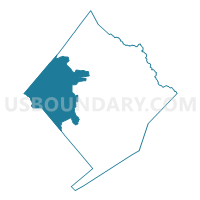
Voting District 0201, Colorado County, Texas
About
Outline

Summary
| Unique Area Identifier | 671697 |
| Name | Voting District 0201 |
| County | Colorado County |
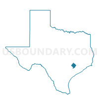
| State | Texas |
| Area (square miles) | 177.88 |
| Land Area (square miles) | 176.86 |
| Water Area (square miles) | 1.03 |
| % of Land Area | 99.42 |
| % of Water Area | 0.58 |
| Latitude of the Internal Point | 29.64181110 |
| Longtitude of the Internal Point | -96.72282980 |
Maps

Graphs
Select a template below for downloading or customizing gragh for Voting District 0201, Colorado County, Texas


Neighbors
Neighoring Voting District (by Name) Neighboring Voting District on the Map
- Voting District 0003, Fayette County, TX
- Voting District 0007, Lavaca County, TX
- Voting District 0019, Lavaca County, TX
- Voting District 0023, Fayette County, TX
- Voting District 0024, Fayette County, TX
- Voting District 0025, Fayette County, TX
- Voting District 0027, Lavaca County, TX
- Voting District 0101, Colorado County, TX
- Voting District 0202, Colorado County, TX
- Voting District 0301, Colorado County, TX
Top 10 Neighboring County Subdivision (by Population) Neighboring County Subdivision on the Map
- Columbus CCD, Colorado County, TX (9,174)
- Hallettsville CCD, Lavaca County, TX (6,975)
- Schulenburg CCD, Fayette County, TX (5,106)
- Weimar CCD, Colorado County, TX (4,769)
- Garwood CCD, Colorado County, TX (2,162)
- Fayetteville CCD, Fayette County, TX (1,995)
Top 10 Neighboring Place (by Population) Neighboring Place on the Map
Top 10 Neighboring Unified School District (by Population) Neighboring Unified School District on the Map
- La Grange Independent School District, TX (11,989)
- Columbus Independent School District, TX (10,195)
- Rice Consolidated Independent School District, TX (6,843)
- Hallettsville Independent School District, TX (6,840)
- Schulenburg Independent School District, TX (5,168)
- Weimar Independent School District, TX (4,500)
Top 10 Neighboring State Legislative District Lower Chamber (by Population) Neighboring State Legislative District Lower Chamber on the Map
Top 10 Neighboring State Legislative District Upper Chamber (by Population) Neighboring State Legislative District Upper Chamber on the Map
Top 10 Neighboring 111th Congressional District (by Population) Neighboring 111th Congressional District on the Map
Top 10 Neighboring Census Tract (by Population) Neighboring Census Tract on the Map
- Census Tract 9706, Fayette County, TX (5,106)
- Census Tract 7504, Colorado County, TX (5,027)
- Census Tract 7503, Colorado County, TX (4,769)
- Census Tract 7505, Colorado County, TX (4,147)
- Census Tract 1, Lavaca County, TX (3,431)
- Census Tract 7502, Colorado County, TX (2,162)
- Census Tract 9707, Fayette County, TX (1,995)
Top 10 Neighboring 5-Digit ZIP Code Tabulation Area (by Population) Neighboring 5-Digit ZIP Code Tabulation Area on the Map
- 77964, TX (7,569)
- 78934, TX (6,712)
- 78956, TX (5,381)
- 78962, TX (4,733)
- 77475, TX (773)
- 78938, TX (471)
- 78943, TX (352)
- 77470, TX (338)
- 78951, TX (26)